
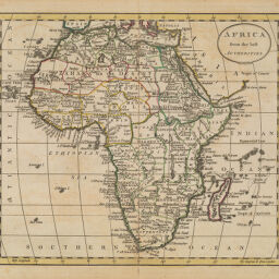
Africa the Best Authorities
Permalink
https://digital.library.illinois.edu/items/29471e60-e946-0133-1d3d-0050569601ca-1
This item is in the public domain.
Descriptive Information
| Title | Africa the Best Authorities |
| Date | 1795 |
| Dimensions | 18.5 x 21.5 cm |
| Cartographic Scale | 1:50,000,000 |
| Notes | Similar to Map by Amos Doolittle in Jeddiah Morse's The American Universal Geography, Part II. |
| Coverage-Spatial | Africa |
| Genre | Maps |
| Language | English |
| Physical Location | Professor Thomas Bassett Personal Collection |
| Map ID | afm0003174 |
| Rights | No Copyright - United States |
| Rights Description | This item is in the public domain. |
| Collection Title | Maps of Africa to 1900 |
| Repository | Rare Book & Manuscript Library |
| Type | Cartographic material |
| Collection | Maps of Africa to 1900 |
Download Options
|
Africa the Best Authorities |
Contact us
for questions and to provide feedback.