
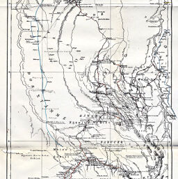
Originalkarte von Dr. C. Schweinfurth's Reisen im Ober Nilcebiete, 1869 & 1870…
Permalink
https://digital.library.illinois.edu/items/29643c70-e946-0133-1d3d-0050569601ca-6
This item is in the public domain.
Descriptive Information
| Title | Originalkarte von Dr. C. Schweinfurth's Reisen im Ober Nilcebiete, 1869 & 1870… |
| Creator | Habenicht, Hermann, 1844-1917 |
| Date | 1871 |
| Dimensions | 64 x 24.5 cm |
| Place of Publication | Germany |
| Cartographic Scale | 1:1,080,000 |
| Notes | Includes 1 inset map (scale 1:1,080,000): Übersichtskarte des W. Obern Nilcebiets. |
| Coverage-Spatial | Congo (Democratic Republic) |
| Subject | |
| Genre | Maps |
| Language | German |
| Color | Hand colored |
| Technique | Lithography |
| Source | Petermanns geographische Mitteilungen, V. 17, plate 7. |
| Physical Location | stx |
| Map No. in Bassett and Scheven Bibliography | 1148 |
| Call Number | Q_910_5PE |
| Map ID | afm0001148 |
| Rights | No Copyright - United States |
| Rights Description | This item is in the public domain. |
| Collection Title | Maps of Africa to 1900 |
| Repository | Rare Book & Manuscript Library |
| Type | Cartographic material |
| Collection | Maps of Africa to 1900 |
Download Options
|
Originalkarte von Dr. C. Schweinfurth's Reisen im Ober Nilcebiete, 1869 & 1870… |
Contact us
for questions and to provide feedback.