
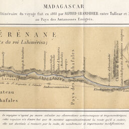
Madagascar: Croquis Itinéraire du voyage fait en 1868 par Alfred Grandidier entre Tullear et Saloubé au Pays des Antanosses Emigrés
Permalink
https://digital.library.illinois.edu/items/29695f90-e946-0133-1d3d-0050569601ca-1
This item is in the public domain.
Descriptive Information
| Title | Madagascar: Croquis Itinéraire du voyage fait en 1868 par Alfred Grandidier entre Tullear et Saloubé au Pays des Antanosses Emigrés |
| Date | 1872 |
| Dimensions | 9.2 x 34.4 cm |
| Place of Publication | France |
| Cartographic Scale | 1:500,000 |
| Coverage-Spatial | Africa, Eastern |
| Genre | Maps |
| Language | French |
| Color | Printed color |
| Technique | Lithography |
| Source | Bulletin de la Société de géographie, ser. 6, V. 3, between pp. 256-257. |
| Physical Location | stx |
| Map No. in Bassett and Scheven Bibliography | 1149 |
| Call Number | 910_6SOGEASER_6 |
| Map ID | afm0001149 |
| Rights | No Copyright - United States |
| Rights Description | This item is in the public domain. |
| Collection Title | Maps of Africa to 1900 |
| Repository | Rare Book & Manuscript Library |
| Type | Cartographic material |
| Collection | Maps of Africa to 1900 |
Download Options
|
Madagascar: Croquis Itinéraire du voyage fait en 1868 par Alfred Grandidier entre Tullear et Saloubé au Pays des Antanosses Emigrés |
Contact us
for questions and to provide feedback.