
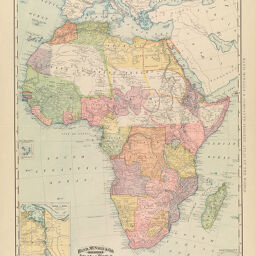
Map of Africa
Permalink
https://digital.library.illinois.edu/items/2990b6c0-e946-0133-1d3d-0050569601ca-b
This item is in the public domain.
Descriptive Information
| Title | Map of Africa |
| Creator | Rand McNally and Company |
| Date | 1892 |
| Dimensions | 66 x 48.5 cm |
| Place of Publication | Chicago (Ill.) |
| Cartographic Scale | 1:14,000,000 |
| Notes | Inset of Canal of Suez. |
| Coverage-Spatial | Africa |
| Genre | Maps |
| Language | English |
| Source | Indexed Atlas of the World, Chicago, 1892, p. 539. |
| Physical Location | Professor Thomas Bassett Personal Collection |
| Bibliography |
|
| Map ID | afm0003145 |
| Rights | No Copyright - United States |
| Rights Description | This item is in the public domain. |
| Collection Title | Maps of Africa to 1900 |
| Repository | Rare Book & Manuscript Library |
| Type | Cartographic material |
| Collection | Maps of Africa to 1900 |
Download Options
|
Map of Africa |
Contact us
for questions and to provide feedback.