
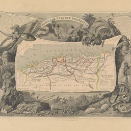
Algérie, Colonie Française
Permalink
https://digital.library.illinois.edu/items/29b04890-e946-0133-1d3d-0050569601ca-e
This item is in the public domain.
Descriptive Information
| Title | Algérie, Colonie Française |
| Creator | Levasseur, Victor |
| Date | 1845 |
| Dimensions | 87.30 x 44 cm |
| Place of Publication | Paris (France) |
| Cartographic Scale | 1:4,700,000 |
| Notes | Top right: Région du Sud, N. |
| Coverage-Spatial | Africa, North |
| Genre | Maps |
| Language | French |
| Source | Atlas National Illustré, Paris, 1845 |
| Physical Location | Professor Thomas Bassett Personal Collection |
| Map ID | afm0003132 |
| Rights | No Copyright - United States |
| Rights Description | This item is in the public domain. |
| Collection Title | Maps of Africa to 1900 |
| Repository | Rare Book & Manuscript Library |
| Type | Cartographic material |
| Collection | Maps of Africa to 1900 |
Download Options
|
Algérie, Colonie Française |
Contact us
for questions and to provide feedback.