
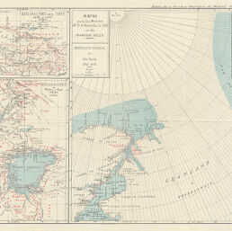
Exploraciones de Stanley y Gessi 1875-1876
Permalink
https://digital.library.illinois.edu/items/29d321d0-e946-0133-1d3d-0050569601ca-3
This item is in the public domain.
Descriptive Information
| Title | Exploraciones de Stanley y Gessi 1875-1876 |
| Creator | Sociedad Geográfica de Madrid |
| Date | 1876 |
| Dimensions | 20 x 15.2 cm |
| Place of Publication | Spain |
| Cartographic Scale | 1:5,000,000 |
| Notes | Part of a larger plate (11x17) with three non-Africa maps. |
| Coverage-Spatial | Africa, Eastern |
| Genre | Maps |
| Language | Spanish |
| Color | Printed color |
| Technique | Lithography and aquatint |
| Source | Boletín de la Real Sociedad Geográfica, V. 1, No. 1, between pp. 488-489. |
| Physical Location | stx |
| Map No. in Bassett and Scheven Bibliography | 1176 |
| Call Number | 910_6SOM |
| Map ID | afm0001176 |
| Rights | No Copyright - United States |
| Rights Description | This item is in the public domain. |
| Collection Title | Maps of Africa to 1900 |
| Repository | Rare Book & Manuscript Library |
| Type | Cartographic material |
| Collection | Maps of Africa to 1900 |
Download Options
|
Exploraciones de Stanley y Gessi 1875-1876 |
Contact us
for questions and to provide feedback.