
Africa
Permalink
https://digital.library.illinois.edu/items/2a0c1130-e946-0133-1d3d-0050569601ca-6
This item is in the public domain.
Descriptive Information
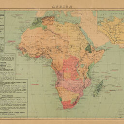
| Title | Africa |
| Creator | d'Azevedo May, Alfredo Oscar |
| Date | 1888 |
| Dimensions | 27 x 37 cm |
| Cartographic Scale | 1:35,000,000 |
| Notes | A good example of the Portugese "rose colored map" that makes claims to the land stretching between Angola and Mozambique. |
| Coverage-Spatial | Africa |
| Genre | Maps |
| Source | Novo Atlas Universal de Historia e Geographia Antiga, Medieval e Moderna. |
| Physical Location | Professor Thomas Bassett Personal Collection |
| Map ID | afm0003088 |
| Rights | No Copyright - United States |
| Rights Description | This item is in the public domain. |
| Collection Title | Maps of Africa to 1900 |
| Repository | Rare Book & Manuscript Library |
| Type | Cartographic material |
| Collection | Maps of Africa to 1900 |
Download Options
Contact us
for questions and to provide feedback.