
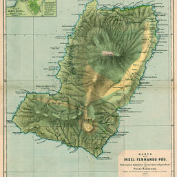
Karte der Insel Fernando Póo
Permalink
https://digital.library.illinois.edu/items/2a89d9e0-e946-0133-1d3d-0050569601ca-c
This item is in the public domain.
Descriptive Information
| Title | Karte der Insel Fernando Póo |
| Creator | Baumann, Oskar, 1864-1899 |
| Date | 1887 |
| Dimensions | 48 x 35 cm |
| Place of Publication | Germany |
| Cartographic Scale | 1:200,000 |
| Notes | Relief shown by landform drawings, depths shown by soundings. Includes 1 inset map (scale 1:20,000): Plan von Santa Isabel. |
| Coverage-Spatial | Fernando Po (Equatorial Guinea) |
| Subject | |
| Genre | Maps |
| Language | German |
| Color | Printed color |
| Source | Petermanns geographische Mitteilungen, V. 33, plate 14. |
| Physical Location | stx |
| Map No. in Bassett and Scheven Bibliography | 2413 |
| Call Number | Q_910_5PE |
| Map ID | afm0002413 |
| Rights | No Copyright - United States |
| Rights Description | This item is in the public domain. |
| Collection Title | Maps of Africa to 1900 |
| Repository | Rare Book & Manuscript Library |
| Type | Cartographic material |
| Collection | Maps of Africa to 1900 |
Download Options
|
Karte der Insel Fernando Póo |
Contact us
for questions and to provide feedback.