
Ilha de S. Thomé parte mais cultivada
Permalink
https://digital.library.illinois.edu/items/2aa13ae0-e946-0133-1d3d-0050569601ca-3
This item is in the public domain.
Descriptive Information
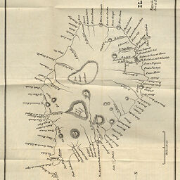
| Title | Ilha de S. Thomé parte mais cultivada |
| Creator | Nogueira, A.F. |
| Date | 1884 |
| Dimensions | 37.5 x 46.2 cm |
| Place of Publication | Portugal |
| Cartographic Scale | 1:70,000 |
| Notes | Relief shown by hachures. |
| Coverage-Spatial | Sao Tome and Principe |
| Subject | |
| Genre | Maps |
| Language | Portuguese |
| Color | Bitonal |
| Technique | Lithography |
| Source | Boletim, V. 5, between pp. 454-455. |
| Physical Location | stx |
| Map No. in Bassett and Scheven Bibliography | 2412 |
| Call Number | 910_6SOL |
| Map ID | afm0002412 |
| Rights | No Copyright - United States |
| Rights Description | This item is in the public domain. |
| Collection Title | Maps of Africa to 1900 |
| Repository | Rare Book & Manuscript Library |
| Type | Cartographic material |
| Collection | Maps of Africa to 1900 |
Download Options
|
Ilha de S. Thomé parte mais cultivada |
Contact us
for questions and to provide feedback.