
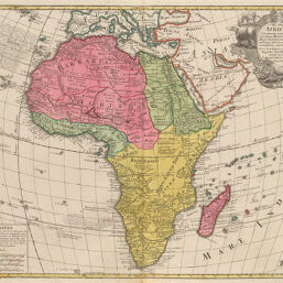
Africa
Permalink
https://digital.library.illinois.edu/items/2b1b8e70-e946-0133-1d3d-0050569601ca-f
This item is in the public domain.
Descriptive Information
| Title | Africa |
| Creator | L'Isle, Guillaume de, 1675-1726 |
| Date | 1702 |
| Dimensions | 44.3 x 57.3 cm |
| Place of Publication | Germany |
| Cartographic Scale | 1:20,500,000 |
| Coverage-Spatial | Africa |
| Genre | Maps |
| Source | Maximvs atlantvm, V. 4, p. 267. |
| Physical Location | rbx |
| Map No. in Bassett and Scheven Bibliography | 52 |
| Call Number | XF_912SE81M |
| Map ID | afm0000052 |
| Rights | No Copyright - United States |
| Rights Description | This item is in the public domain. |
| Collection Title | Maps of Africa to 1900 |
| Repository | Rare Book & Manuscript Library |
| Type | Cartographic material |
| Collection | Maps of Africa to 1900 |
Download Options
Contact us
for questions and to provide feedback.