
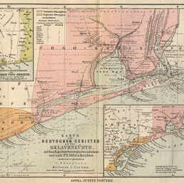
Karte des Deutschen Gebietes an der Sklavenküste
Permalink
https://digital.library.illinois.edu/items/2b8414a0-e946-0133-1d3d-0050569601ca-0
This item is in the public domain.
Descriptive Information
| Title | Karte des Deutschen Gebietes an der Sklavenküste |
| Creator | Langhans, Paul, 1867-1952 |
| Date | 1885 |
| Dimensions | 22.2 x 35.6 cm |
| Place of Publication | Germany |
| Cartographic Scale | 1:250,000 |
| Notes | Relief shown by hachures, depths shown by soundings and isolines. Includes 2 inset maps: Karte der Sklavenkuste vom Volta bis Weida (scale 1:1,000,000) -- Das Unerforschte Hinterland des Deutschen Togo-Gebietes (scale 1:2,000,000). |
| Coverage-Spatial | Togoland |
| Subject | |
| Genre | Maps |
| Language | German |
| Color | Printed color |
| Source | Petermanns geographische Mitteilungen, V. 31, plate 11. |
| Physical Location | stx |
| Map No. in Bassett and Scheven Bibliography | 2279 |
| Call Number | Q_910_5PE |
| Map ID | afm0002279 |
| Rights | No Copyright - United States |
| Rights Description | This item is in the public domain. |
| Collection Title | Maps of Africa to 1900 |
| Repository | Rare Book & Manuscript Library |
| Type | Cartographic material |
| Collection | Maps of Africa to 1900 |
Download Options
|
Karte des Deutschen Gebietes an der Sklavenküste |
Contact us
for questions and to provide feedback.