
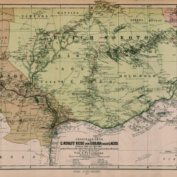
Originalkarte von G. Rohlfs' Reise von Gudjba nach Lagos Februar 1866 bis Mai 1867 nebst Übersicht aller übrigen Europäischen Reisen in diesem Gebiet
Permalink
https://digital.library.illinois.edu/items/2bea5fd0-e946-0133-1d3d-0050569601ca-f
This item is in the public domain.
Descriptive Information
| Title | Originalkarte von G. Rohlfs' Reise von Gudjba nach Lagos Februar 1866 bis Mai 1867 nebst Übersicht aller übrigen Europäischen Reisen in diesem Gebiet |
| Creator | Petermann, A. (August), 1822-1878 |
| Date | 1872 |
| Dimensions | 24.7 x 42.7 cm |
| Place of Publication | Germany |
| Cartographic Scale | 1:2,500,000 |
| Notes | Relief shown by contours, hachures and spot heights. Explorers' routes indicated by color or dashed lines. |
| Coverage-Spatial | Gujuba (Nigeria) |
| Subject | |
| Genre | Maps |
| Language | German |
| Color | Printed color |
| Source | Petermanns geographische Mitteilungen, V. 7, No. 34, after p. 124. |
| Physical Location | stx |
| Map No. in Bassett and Scheven Bibliography | 2239 |
| Call Number | Q_910_5PE |
| Map ID | afm0002239 |
| Rights | No Copyright - United States |
| Rights Description | This item is in the public domain. |
| Collection Title | Maps of Africa to 1900 |
| Repository | Rare Book & Manuscript Library |
| Type | Cartographic material |
| Collection | Maps of Africa to 1900 |
Download Options
|
Originalkarte von G. Rohlfs' Reise von Gudjba nach Lagos Februar 1866 bis Mai 1867 nebst Übersicht aller übrigen Europäischen Reisen in diesem Gebiet |
Contact us
for questions and to provide feedback.