
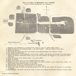
Plan von Kuka
Permalink
https://digital.library.illinois.edu/items/2bf04990-e946-0133-1d3d-0050569601ca-4
This item is in the public domain.
Descriptive Information
| Title | Plan von Kuka |
| Creator | Petermann, A. (August), 1822-1878 |
| Date | 1871 |
| Dimensions | 9.3 x 16 cm |
| Cartographic Scale | 1:40,000 |
| Notes | Includes detailed descriptions of structures and their uses. |
| Coverage-Spatial | Kukawa (Nigeria) |
| Subject | |
| Genre | Maps |
| Language | German |
| Color | Bitonal |
| Technique | Other |
| Source | Petermanns geographische Mitteilungen, V. 17, p. 68. |
| Physical Location | stx |
| Map No. in Bassett and Scheven Bibliography | 2237 |
| Call Number | Q_910_5PE |
| Map ID | afm0002237 |
| Rights | No Copyright - United States |
| Rights Description | This item is in the public domain. |
| Collection Title | Maps of Africa to 1900 |
| Repository | Rare Book & Manuscript Library |
| Type | Cartographic material |
| Collection | Maps of Africa to 1900 |
Download Options
|
Plan von Kuka |
Contact us
for questions and to provide feedback.