
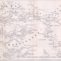
Carte du Cours Inférieur de la Gambie pur servir au voyage de M. Borel
Permalink
https://digital.library.illinois.edu/items/2bff3830-e946-0133-1d3d-0050569601ca-e
This item is in the public domain.
Descriptive Information
| Title | Carte du Cours Inférieur de la Gambie pur servir au voyage de M. Borel |
| Creator | Chaix, Paul, 1808-1901 |
| Date | 1866 |
| Dimensions | 22.4 x 39 cm |
| Place of Publication | Switzerland |
| Cartographic Scale | 1:1,600,000 |
| Coverage-Spatial | Casamance River (Senegal) |
| Subject | |
| Genre | Maps |
| Language | French |
| Color | Bitonal |
| Technique | Lithography |
| Source | Le Globe : bulletin et mémoires de la Société de géographie de Genève, V. 5, between pp. 31-32. |
| Physical Location | stx |
| Map No. in Bassett and Scheven Bibliography | 2229 |
| Call Number | 910_5GLO |
| Map ID | afm0002229 |
| Rights | No Copyright - United States |
| Rights Description | This item is in the public domain. |
| Collection Title | Maps of Africa to 1900 |
| Repository | Rare Book & Manuscript Library |
| Type | Cartographic material |
| Collection | Maps of Africa to 1900 |
Download Options
|
Carte du Cours Inférieur de la Gambie pur servir au voyage de M. Borel |
Contact us
for questions and to provide feedback.