
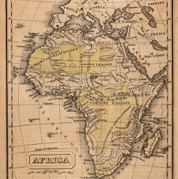
Africa
Permalink
https://digital.library.illinois.edu/items/2c2d6fd0-e946-0133-1d3d-0050569601ca-2
This item is in the public domain.
Descriptive Information
| Title | Africa |
| Creator | Edmands, B. Franklin (Benjamin Franklin), 1807-1874 |
| Date | 1833 |
| Dimensions | 18 x 14.5 cm |
| Place of Publication | United States |
| Cartographic Scale | 1:75,000,000 |
| Coverage-Spatial | Africa |
| Genre | Maps |
| Color | Hand colored |
| Technique | Etched or engraved |
| Source | Boston School Atlas, p. 72. |
| Physical Location | mar |
| Map No. in Bassett and Scheven Bibliography | 181 |
| Call Number | 912ED5B1833 |
| Map ID | afm0000181 |
| Rights | No Copyright - United States |
| Rights Description | This item is in the public domain. |
| Collection Title | Maps of Africa to 1900 |
| Repository | Rare Book & Manuscript Library |
| Type | Cartographic material |
| Collection | Maps of Africa to 1900 |
Download Options
Contact us
for questions and to provide feedback.