
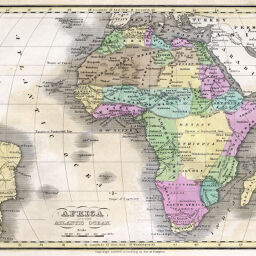
Africa and the Atlantic Ocean
Permalink
https://digital.library.illinois.edu/items/2c389a80-e946-0133-1d3d-0050569601ca-7
This item is in the public domain.
Descriptive Information
| Title | Africa and the Atlantic Ocean |
| Creator | Huntington, Nathaniel G. (Nathaniel Gilbert), 1785-1848 |
| Date | 1834 |
| Dimensions | 20 x 25 cm |
| Place of Publication | United States |
| Cartographic Scale | 1:46,000,000 |
| Notes | Relief shown by hachures. |
| Coverage-Spatial | Africa |
| Subject | |
| Genre | Maps |
| Language | English |
| Color | Printed color |
| Technique | Etched or engraved |
| Source | Huntington's School Atlas, plate 15. |
| Physical Location | stx and loose sheet: G83001833H8 |
| Map No. in Bassett and Scheven Bibliography | 184 |
| Call Number | Q_912H92S1834 |
| Map ID | afm0000184 |
| Rights | No Copyright - United States |
| Rights Description | This item is in the public domain. |
| Collection Title | Maps of Africa to 1900 |
| Repository | Rare Book & Manuscript Library |
| Type | Cartographic material |
| Collection | Maps of Africa to 1900 |
Download Options
|
Africa and the Atlantic Ocean |
Contact us
for questions and to provide feedback.