
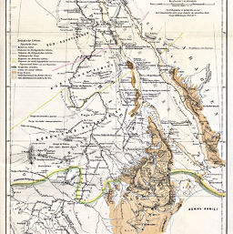
Zoo-Geographische Karte des Nilgebietes und der Uferländer des Rothen Meeres von M. Th. V. Heuglin, 1869
Permalink
https://digital.library.illinois.edu/items/2cc88930-e946-0133-1d3d-0050569601ca-6
This item is in the public domain.
Descriptive Information
| Title | Zoo-Geographische Karte des Nilgebietes und der Uferländer des Rothen Meeres von M. Th. V. Heuglin, 1869 |
| Creator | Hueglin, T. von |
| Date | 1869 |
| Dimensions | 33 x 22.3 cm |
| Cartographic Scale | 1:10,000,000 |
| Notes | Relief shown by hachures. |
| Coverage-Spatial | Africa, North |
| Subject | |
| Genre | Maps |
| Language | German |
| Color | Printed color |
| Technique | Lithography |
| Source | Petermanns geographische Mitteilungen; V. 15; plate 21. |
| Physical Location | stx |
| Map No. in Bassett and Scheven Bibliography | 259 |
| Call Number | Q_910_5PE |
| Map ID | afm0000259 |
| Rights | No Copyright - United States |
| Rights Description | This item is in the public domain. |
| Collection Title | Maps of Africa to 1900 |
| Repository | Rare Book & Manuscript Library |
| Type | Cartographic material |
| Collection | Maps of Africa to 1900 |
Download Options
|
Zoo-Geographische Karte des Nilgebietes und der Uferländer des Rothen Meeres von M. Th. V. Heuglin, 1869 |
Contact us
for questions and to provide feedback.