
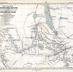
Originalkarte der Portugiesischen Reisen in Inner-Afrika…
Permalink
https://digital.library.illinois.edu/items/2cd17f00-e946-0133-1d3d-0050569601ca-c
This item is in the public domain.
Descriptive Information
| Title | Originalkarte der Portugiesischen Reisen in Inner-Afrika… |
| Creator | Hanemann, H. |
| Date | 1870 |
| Dimensions | 24.7 x 30.2 cm |
| Cartographic Scale | 1:4,500,000 |
| Notes | Relief shown by hachures. Eleven routes of exploration indicated by color or unique line. |
| Coverage-Spatial | Great Lakes (Africa) |
| Subject | |
| Genre | Maps |
| Language | German |
| Color | Printed color |
| Technique | Lithography |
| Source | Petermanns geographische Mitteilungen, V. 16, plate 9. |
| Physical Location | stx |
| Map No. in Bassett and Scheven Bibliography | 261 |
| Call Number | Q_910_5PE |
| Map ID | afm0000261 |
| Rights | No Copyright - United States |
| Rights Description | This item is in the public domain. |
| Collection Title | Maps of Africa to 1900 |
| Repository | Rare Book & Manuscript Library |
| Type | Cartographic material |
| Collection | Maps of Africa to 1900 |
Download Options
|
Originalkarte der Portugiesischen Reisen in Inner-Afrika… |
Contact us
for questions and to provide feedback.