
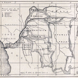
Divisions Administratives de l'Etat du Congo
Permalink
https://digital.library.illinois.edu/items/2d372220-e946-0133-1d3d-0050569601ca-6
This item is in the public domain.
Descriptive Information
| Title | Divisions Administratives de l'Etat du Congo |
| Creator | Garnier, Christian |
| Date | 1897 |
| Dimensions | 10.6 x 12 cm |
| Cartographic Scale | 1:21,000,000 |
| Notes | Greenwich and Paris meridians. |
| Coverage-Spatial | French Equatorial Africa |
| Subject | |
| Genre | Maps |
| Language | French |
| Color | Bitonal |
| Technique | Lithography (?) |
| Source | Revue de geographie, V. 41, p. 426. |
| Physical Location | stx |
| Map No. in Bassett and Scheven Bibliography | 2098 |
| Call Number | 910_5RE |
| Map ID | afm0002098 |
| Rights | No Copyright - United States |
| Rights Description | This item is in the public domain. |
| Collection Title | Maps of Africa to 1900 |
| Repository | Rare Book & Manuscript Library |
| Type | Cartographic material |
| Collection | Maps of Africa to 1900 |
Download Options
|
Divisions Administratives de l'Etat du Congo |
Contact us
for questions and to provide feedback.