
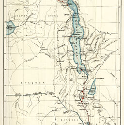
General map showing the Eastern route to Central Africa from Kilimane to Lake Tanganyika
Permalink
https://digital.library.illinois.edu/items/2d6b4c90-e946-0133-1d3d-0050569601ca-c
This item is in the public domain.
Descriptive Information
| Title | General map showing the Eastern route to Central Africa from Kilimane to Lake Tanganyika |
| Creator | Bartholomew, J. G. (John George), 1860-1920 |
| Date | 1885 |
| Dimensions | 22.6 x 14.9 cm |
| Place of Publication | England |
| Cartographic Scale | 1:5,500,000 |
| Notes | Relief shown by hachures and pictorially. |
| Coverage-Spatial | Great Lakes (Africa) |
| Subject | |
| Genre | Maps |
| Language | English |
| Color | Printed color |
| Technique | Lithography |
| Source | Scottish geographical magazine, V. 1, between pp. 112-113. |
| Physical Location | stx |
| Map No. in Bassett and Scheven Bibliography | 336 |
| Call Number | 910_5SC |
| Map ID | afm0000336 |
| Rights | No Copyright - United States |
| Rights Description | This item is in the public domain. |
| Collection Title | Maps of Africa to 1900 |
| Repository | Rare Book & Manuscript Library |
| Type | Cartographic material |
| Collection | Maps of Africa to 1900 |
Download Options
|
General map showing the Eastern route to Central Africa from Kilimane to Lake Tanganyika |
Contact us
for questions and to provide feedback.