
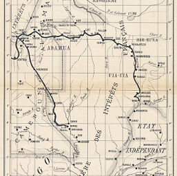
La Région entre le Congo et le Tshad Divisions d'aprés les nouvelles Conventions
Permalink
https://digital.library.illinois.edu/items/2d902410-e946-0133-1d3d-0050569601ca-b
This item is in the public domain.
Descriptive Information
| Title | La Région entre le Congo et le Tshad Divisions d'aprés les nouvelles Conventions |
| Creator | Société de Géographie de Toulouse |
| Date | 1894 |
| Dimensions | 25.7 x 17.1 cm |
| Place of Publication | France |
| Cartographic Scale | 1:6,500,000 |
| Notes | Shows the boundaries of the "Sphere des intérets. |
| Coverage-Spatial | Congo (Brazzaville) |
| Subject | |
| Genre | Maps |
| Language | French |
| Color | Bitonal |
| Technique | Lithography |
| Source | Bulletin de la Société de Géographie de Toulouse, V. 13, between pp. 100-101. |
| Physical Location | stx |
| Map No. in Bassett and Scheven Bibliography | 2077 |
| Call Number | 910_6SOCT |
| Map ID | afm0002077 |
| Rights | No Copyright - United States |
| Rights Description | This item is in the public domain. |
| Collection Title | Maps of Africa to 1900 |
| Repository | Rare Book & Manuscript Library |
| Type | Cartographic material |
| Collection | Maps of Africa to 1900 |
Download Options
|
La Région entre le Congo et le Tshad Divisions d'aprés les nouvelles Conventions |
Contact us
for questions and to provide feedback.