
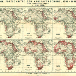
Die Fortschritte der Afrikaforschung, 1788-1888
Permalink
https://digital.library.illinois.edu/items/2dafdb40-e946-0133-1d3d-0050569601ca-e
This item is in the public domain.
Descriptive Information
| Title | Die Fortschritte der Afrikaforschung, 1788-1888 |
| Creator | Supan, Alexander, 1847-1920 |
| Date | 1888 |
| Dimensions | 29.9 x 68.7 cm |
| Cartographic Scale | 1:60,000,000 |
| Notes | Ten maps on 1 sheet showing the expansion of European knowledge and territorial claims between 1790 and 1880. |
| Coverage-Spatial | Africa |
| Subject | |
| Genre | Maps |
| Language | German |
| Color | Printed color |
| Technique | Lithography |
| Source | Petermanns geographische Mitteilungen, V. 34, plate 10. |
| Physical Location | stx |
| Map No. in Bassett and Scheven Bibliography | 367 |
| Call Number | Q_910_5PE |
| Map ID | afm0000367 |
| Rights | No Copyright - United States |
| Rights Description | This item is in the public domain. |
| Collection Title | Maps of Africa to 1900 |
| Repository | Rare Book & Manuscript Library |
| Type | Cartographic material |
| Collection | Maps of Africa to 1900 |
Download Options
|
Die Fortschritte der Afrikaforschung, 1788-1888 |
Contact us
for questions and to provide feedback.