
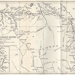
Itinéraire de la Mission Maistre entre l'Oubangui & la Bénoué
Permalink
https://digital.library.illinois.edu/items/2dba2110-e946-0133-1d3d-0050569601ca-a
This item is in the public domain.
Descriptive Information
| Title | Itinéraire de la Mission Maistre entre l'Oubangui & la Bénoué |
| Creator | Maistre, Casimir |
| Date | 1893 |
| Dimensions | 17.2 x 25.9 cm |
| Cartographic Scale | 1:4,000,000 |
| Notes | Includes 1 inset location map: Itinéraire complet. |
| Coverage-Spatial | French Equatorial Africa |
| Subject | |
| Genre | Maps |
| Language | French |
| Color | Bitonal |
| Technique | Lithography |
| Source | Annales de géographie : bulletin de la Société de géographie, V. 3, between pp. 64-65. |
| Physical Location | stx |
| Map No. in Bassett and Scheven Bibliography | 2055 |
| Call Number | 910_5AN |
| Map ID | afm0002055 |
| Rights | No Copyright - United States |
| Rights Description | This item is in the public domain. |
| Collection Title | Maps of Africa to 1900 |
| Repository | Rare Book & Manuscript Library |
| Type | Cartographic material |
| Collection | Maps of Africa to 1900 |
Download Options
|
Itinéraire de la Mission Maistre entre l'Oubangui & la Bénoué |
Contact us
for questions and to provide feedback.