
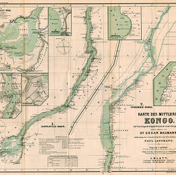
Karte des Mittleren Kongo
Permalink
https://digital.library.illinois.edu/items/2e6be510-e946-0133-1d3d-0050569601ca-7
This item is in the public domain.
Descriptive Information
| Title | Karte des Mittleren Kongo |
| Creator | Baumann, Oskar, 1864-1899 |
| Date | 1888 |
| Extent | 1 map in 2 sections with six insets |
| Dimensions | 47 x 57.1 cm |
| Cartographic Scale | 1:430,000 |
| Notes | Der Stanley-Pool -- Kwamouth -- Leopoldville -- Kimpoko -- Lukolela -- Bolobo. Relief shown by shading and spot heights, depths shown by isolines. |
| Coverage-Spatial | Congo River |
| Subject | |
| Genre | Maps |
| Language | German |
| Color | Printed color |
| Source | Mitteilungen der Österreichischen Geographischen Gesellschaft, V. 31, between pp. 576-577. |
| Physical Location | stx |
| Map No. in Bassett and Scheven Bibliography | 1991 |
| Call Number | 910_5GEOW |
| Map ID | afm0001991 |
| Rights | No Copyright - United States |
| Rights Description | This item is in the public domain. |
| Collection Title | Maps of Africa to 1900 |
| Repository | Rare Book & Manuscript Library |
| Type | Cartographic material |
| Collection | Maps of Africa to 1900 |
Download Options
|
Karte des Mittleren Kongo |
Contact us
for questions and to provide feedback.