
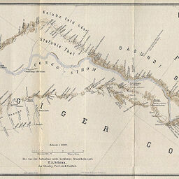
Karten der Karawanen-Routen im gebiete der Livingstone-Fälle des Unteren Congo
Permalink
https://digital.library.illinois.edu/items/2ecec2e0-e946-0133-1d3d-0050569601ca-6
This item is in the public domain.
Descriptive Information
| Title | Karten der Karawanen-Routen im gebiete der Livingstone-Fälle des Unteren Congo |
| Creator | Baumann, Oskar, 1864-1899 |
| Date | 1887 |
| Dimensions | 21.7 x 82.5 cm |
| Place of Publication | Austria |
| Cartographic Scale | 1:400,000 |
| Notes | Relief shown by hachures and spot heights. |
| Coverage-Spatial | Malebo Pool (Congo (Brazzaville) and Congo (Democratic Republic)) |
| Subject | |
| Genre | Maps |
| Language | German |
| Color | Printed color |
| Technique | Lithography |
| Source | Mitteilungen der Osterreichischen Geographischen Gesellschaft, V. 30, after p. 682. |
| Physical Location | stx |
| Map No. in Bassett and Scheven Bibliography | 1970 |
| Call Number | 910_5GEOW |
| Map ID | afm0001970 |
| Rights | No Copyright - United States |
| Rights Description | This item is in the public domain. |
| Collection Title | Maps of Africa to 1900 |
| Repository | Rare Book & Manuscript Library |
| Type | Cartographic material |
| Collection | Maps of Africa to 1900 |
Download Options
|
Karten der Karawanen-Routen im gebiete der Livingstone-Fälle des Unteren Congo |
Contact us
for questions and to provide feedback.