
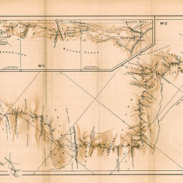
Itinéraire de l'Ogooué a l'Embouchure du Ngongo par L. Mizon Lieutenant de Vaisseau 1881-1883
Permalink
https://digital.library.illinois.edu/items/2ed9c9d0-e946-0133-1d3d-0050569601ca-1
This item is in the public domain.
Descriptive Information
| Title | Itinéraire de l'Ogooué a l'Embouchure du Ngongo par L. Mizon Lieutenant de Vaisseau 1881-1883 |
| Creator | Société de Géographie (France) |
| Date | 1886 |
| Extent | 1 map in 2 sections |
| Dimensions | 77.5 x 29.5 cm |
| Place of Publication | France |
| Cartographic Scale | 1:500,000 |
| Notes | Relief shown by form lines and spot heights. |
| Coverage-Spatial | Ngongo River (Gabon) |
| Subject | |
| Genre | Maps |
| Language | French |
| Color | Printed color |
| Source | Bulletin de la Société de géographie, ser. 7, V. 7, after p. 695. |
| Physical Location | stx |
| Map No. in Bassett and Scheven Bibliography | 1965 |
| Call Number | 910_6SOGEASER_7 |
| Map ID | afm0001965 |
| Rights | No Copyright - United States |
| Rights Description | This item is in the public domain. |
| Collection Title | Maps of Africa to 1900 |
| Repository | Rare Book & Manuscript Library |
| Type | Cartographic material |
| Collection | Maps of Africa to 1900 |
Download Options
|
Itinéraire de l'Ogooué a l'Embouchure du Ngongo par L. Mizon Lieutenant de Vaisseau 1881-1883 |
Contact us
for questions and to provide feedback.