
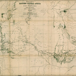
Map of part of Eastern Central Africa shewing the Routes...of Henry M. Stanley whilst in search of Dr. Livingstone
Permalink
https://digital.library.illinois.edu/items/3014fcb0-e946-0133-1d3d-0050569601ca-d
This item is in the public domain.
Descriptive Information
| Title | Map of part of Eastern Central Africa shewing the Routes...of Henry M. Stanley whilst in search of Dr. Livingstone |
| Creator | Stanford, Edward, 1827-1904 |
| Date | 1872 |
| Dimensions | 48 x 60.5 cm |
| Place of Publication | England |
| Cartographic Scale | 1:2,080,000 |
| Notes | Relief shown by hachures. |
| Coverage-Spatial | Africa, Central |
| Subject | |
| Genre | Maps |
| Language | English |
| Color | Bitonal |
| Source | Loose sheet |
| Physical Location | max |
| Map No. in Bassett and Scheven Bibliography | 1864 |
| Call Number | G8320_S11871-1872_S7 |
| Map ID | afm0001864 |
| Rights | No Copyright - United States |
| Rights Description | This item is in the public domain. |
| Collection Title | Maps of Africa to 1900 |
| Repository | Rare Book & Manuscript Library |
| Type | Cartographic material |
| Collection | Maps of Africa to 1900 |
Download Options
|
Map of part of Eastern Central Africa shewing the Routes...of Henry M. Stanley whilst in search of Dr. Livingstone |
Contact us
for questions and to provide feedback.