
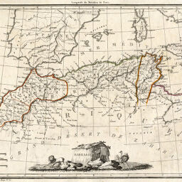
Barbarie
Permalink
https://digital.library.illinois.edu/items/307afcb0-e946-0133-1d3d-0050569601ca-a
This item is in the public domain.
Descriptive Information
| Title | Barbarie |
| Creator | Malte-Brun, Conrad, 1775-1826 |
| Date | 1812 |
| Dimensions | 22 x 29.8 cm |
| Place of Publication | France |
| Cartographic Scale | 1:9,000,000 |
| Notes | Relief shown pictorially. Paris meridian. Decorative cartouche depicts lion, ostrich and hut. |
| Coverage-Spatial | Barbary Coast |
| Subject | |
| Genre | Maps |
| Language | French |
| Color | Hand colored |
| Technique | Etched or engraved |
| Source | Atlas complet du précis de la géographie universelle de M. Malte-Brun, plate 149. |
| Physical Location | maos |
| Map No. in Bassett and Scheven Bibliography | 663 |
| Call Number | Q_912M29A |
| Map ID | afm0000663 |
| Rights | No Copyright - United States |
| Rights Description | This item is in the public domain. |
| Collection Title | Maps of Africa to 1900 |
| Repository | Rare Book & Manuscript Library |
| Type | Cartographic material |
| Collection | Maps of Africa to 1900 |
Download Options
|
Barbarie |
Contact us
for questions and to provide feedback.