
Geological Sketch-Map of Central Africa
Permalink
https://digital.library.illinois.edu/items/30dc85f0-e946-0133-1d3d-0050569601ca-2
This item is in the public domain.
Descriptive Information
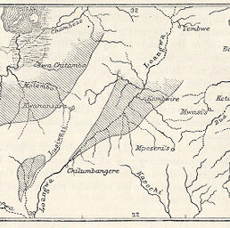
| Title | Geological Sketch-Map of Central Africa |
| Creator | Weller, F. S. |
| Date | 1893 |
| Dimensions | 5.9 x 10.7 cm |
| Place of Publication | England |
| Cartographic Scale | 1:8,000,000 |
| Coverage-Spatial | Congo (Democratic Republic) |
| Subject | |
| Genre | Maps |
| Language | English |
| Color | Hand colored |
| Technique | Lithography |
| Source | The Geographical Journal, V. 1, p. 117. |
| Physical Location | stx |
| Map No. in Bassett and Scheven Bibliography | 1774 |
| Call Number | 910_5GJ |
| Map ID | afm0001774 |
| Rights | No Copyright - United States |
| Rights Description | This item is in the public domain. |
| Collection Title | Maps of Africa to 1900 |
| Repository | Rare Book & Manuscript Library |
| Type | Cartographic material |
| Collection | Maps of Africa to 1900 |
Download Options
|
Geological Sketch-Map of Central Africa |
Contact us
for questions and to provide feedback.