
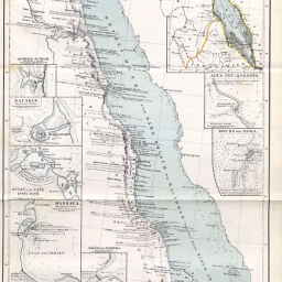
Das Rothe Meer und die Wichtigsten Häfen Westhälfte...Th. von Heuglin's Reise
Permalink
https://digital.library.illinois.edu/items/31035ef0-e946-0133-1d3d-0050569601ca-0
This item is in the public domain.
Descriptive Information
| Title | Das Rothe Meer und die Wichtigsten Häfen Westhälfte...Th. von Heuglin's Reise |
| Creator | Petermann, A. (August), 1822-1878 |
| Date | 1860 |
| Dimensions | 42.5 x 24.4 cm |
| Place of Publication | Germany |
| Cartographic Scale | 1:5,000,000 |
| Notes | Includes 10 inset maps: Scherm Schaab -- Sauakin -- Bucht von Aqiq und Insel Eiro -- Massaua -- Bai von Adulis -- Nokeri od. Nechesia -- Insel Majun od. Perim -- Mocha od. Moka -- Alt & Neu Qosseir -- Skizze vom Rothen Meere. |
| Coverage-Spatial | Eritrea |
| Subject | |
| Genre | Maps |
| Language | German |
| Color | Hand colored |
| Technique | Lithography |
| Source | Petermanns geographische Mitteilungen, V. 6, plate 15. |
| Physical Location | stx |
| Map No. in Bassett and Scheven Bibliography | 722 |
| Call Number | Q_910_5PE |
| Map ID | afm0000722 |
| Rights | No Copyright - United States |
| Rights Description | This item is in the public domain. |
| Collection Title | Maps of Africa to 1900 |
| Repository | Rare Book & Manuscript Library |
| Type | Cartographic material |
| Collection | Maps of Africa to 1900 |
Download Options
|
Das Rothe Meer und die Wichtigsten Häfen Westhälfte...Th. von Heuglin's Reise |
Contact us
for questions and to provide feedback.