
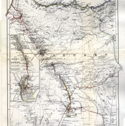
Originalkarte von Gerhard Rohlfs' Reisen in Central & Süd Marokko (Atlas, Tafilet, Draa, & c.), 1862-1864
Permalink
https://digital.library.illinois.edu/items/3136b0f0-e946-0133-1d3d-0050569601ca-e
This item is in the public domain.
Descriptive Information
| Title | Originalkarte von Gerhard Rohlfs' Reisen in Central & Süd Marokko (Atlas, Tafilet, Draa, & c.), 1862-1864 |
| Creator | Hassenstein, Bruno |
| Date | 1865 |
| Dimensions | 42 x 24.5 cm |
| Place of Publication | Germany |
| Cartographic Scale | 1:2,000,000 |
| Notes | Includes 1 inset map (scale 1:1,000,000): Die Oasen von Tafilet. |
| Coverage-Spatial | Morocco |
| Subject | |
| Genre | Maps |
| Language | German |
| Color | Hand colored |
| Technique | Lithography |
| Source | Petermanns geographische Mitteilungen. V. 11, plate 6. |
| Physical Location | stx |
| Map No. in Bassett and Scheven Bibliography | 744 |
| Call Number | Q_910_5PE |
| Map ID | afm0000744 |
| Rights | No Copyright - United States |
| Rights Description | This item is in the public domain. |
| Collection Title | Maps of Africa to 1900 |
| Repository | Rare Book & Manuscript Library |
| Type | Cartographic material |
| Collection | Maps of Africa to 1900 |
Download Options
|
Originalkarte von Gerhard Rohlfs' Reisen in Central & Süd Marokko (Atlas, Tafilet, Draa, & c.), 1862-1864 |
Contact us
for questions and to provide feedback.