
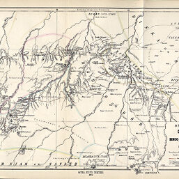
Originalkarte von Dar-Fertit und den anstossenden Bongo-,Djur-& Dinka-Territorien entworfen und gezeichnet von Dr. G. Schweinfurth
Permalink
https://digital.library.illinois.edu/items/3175dad0-e946-0133-1d3d-0050569601ca-7
This item is in the public domain.
Descriptive Information
| Title | Originalkarte von Dar-Fertit und den anstossenden Bongo-,Djur-& Dinka-Territorien entworfen und gezeichnet von Dr. G. Schweinfurth |
| Creator | Breithaupt, G. |
| Date | 1872 |
| Dimensions | 24.4 x 40 cm |
| Place of Publication | Germany |
| Cartographic Scale | 1:1,000,000 |
| Notes | Relief shown by hachures and spot heights. |
| Coverage-Spatial | Sudan |
| Subject | |
| Genre | Maps |
| Language | German |
| Color | Hand colored |
| Technique | Lithography |
| Source | Petermanns geographische Mitteilungen. V. 18, plate 15. |
| Physical Location | stx |
| Map No. in Bassett and Scheven Bibliography | 774 |
| Call Number | Q_910_5PE |
| Map ID | afm0000774 |
| Rights | No Copyright - United States |
| Rights Description | This item is in the public domain. |
| Collection Title | Maps of Africa to 1900 |
| Repository | Rare Book & Manuscript Library |
| Type | Cartographic material |
| Collection | Maps of Africa to 1900 |
Download Options
|
Originalkarte von Dar-Fertit und den anstossenden Bongo-,Djur-& Dinka-Territorien entworfen und gezeichnet von Dr. G. Schweinfurth |
Contact us
for questions and to provide feedback.