


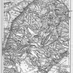
Ost-Griqua-und Pondo-Land nach C. Henkel's Karte und anderen Quellen
Permalink
https://digital.library.illinois.edu/items/31e22720-e946-0133-1d3d-0050569601ca-3
This item is in the public domain.
Descriptive Information
| Title | Ost-Griqua-und Pondo-Land nach C. Henkel's Karte und anderen Quellen |
| Creator | Domann, B. (Bruno) |
| Date | 1881 |
| Dimensions | 24.2 x 19.2 cm |
| Place of Publication | Germany |
| Cartographic Scale | 1:1,000,000 |
| Notes | Relief shown by landform drawings. |
| Coverage-Spatial | Lesotho |
| Subject | |
| Genre | Maps |
| Language | German |
| Color | Bitonal |
| Source | Petermanns geographische Mitteilungen, V. 27, plate 10. |
| Physical Location | stx |
| Map No. in Bassett and Scheven Bibliography | 1693 |
| Call Number | Q_910_5PE |
| Map ID | afm0001693 |
| Rights | No Copyright - United States |
| Rights Description | This item is in the public domain. |
| Collection Title | Maps of Africa to 1900 |
| Repository | Rare Book & Manuscript Library |
| Type | Cartographic material |
| Collection | Maps of Africa to 1900 |
Download Options
|
Ost-Griqua-und Pondo-Land nach C. Henkel's Karte und anderen Quellen |
Contact us
for questions and to provide feedback.