
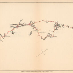
Route Map of A.C. Bailie's Journey from Barkly to Gubuluwayo
Permalink
https://digital.library.illinois.edu/items/3209d910-e946-0133-1d3d-0050569601ca-1
This item is in the public domain.
Descriptive Information
| Title | Route Map of A.C. Bailie's Journey from Barkly to Gubuluwayo |
| Creator | Royal Geographical Society (Great Britain) |
| Date | 1878 |
| Dimensions | 17.9 x 42 cm |
| Place of Publication | England |
| Cartographic Scale | No scale |
| Coverage-Spatial | Africa, Southern |
| Genre | Maps |
| Language | English |
| Source | Journal of the Royal Geographic Society, V., 48, between pp. 286-287. |
| Physical Location | rbx |
| Map No. in Bassett and Scheven Bibliography | 1680 |
| Call Number | 910_6ROJ (Online resource, http://www_library_uiuc_edu/orr/results_php?resid=35994) |
| Map ID | afm0001680 |
| Rights | No Copyright - United States |
| Rights Description | This item is in the public domain. |
| Collection Title | Maps of Africa to 1900 |
| Repository | Rare Book & Manuscript Library |
| Type | Cartographic material |
| Collection | Maps of Africa to 1900 |
Download Options
|
Route Map of A.C. Bailie's Journey from Barkly to Gubuluwayo |
Contact us
for questions and to provide feedback.