
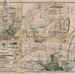
Original Map of the Transvaal or South-African Republic
Permalink
https://digital.library.illinois.edu/items/321a8d40-e946-0133-1d3d-0050569601ca-8
This item is in the public domain.
Descriptive Information
| Title | Original Map of the Transvaal or South-African Republic |
| Creator | Merensky, Alexander, 1837-1918 |
| Date | 1868 |
| Dimensions | 44.8 x 58.2 cm |
| Place of Publication | Germany |
| Cartographic Scale | 1:850,000 |
| Notes | Relief shown by hachures. Includes 4 inset maps: Reduced Map of the Transvaal Republic ... -- Plan of Rustenburg -- Plan of Pretoria -- Plan of Potchesfstroom. |
| Coverage-Spatial | Transvaal (Colony) |
| Subject | |
| Genre | Maps |
| Language | English |
| Color | Hand colored |
| Technique | Lithography |
| Source | Petermanns geographische Mitteilungen, V. 5, No. 24, after p. 24. |
| Physical Location | stx |
| Map No. in Bassett and Scheven Bibliography | 1669 |
| Call Number | Q_910_5PE |
| Map ID | afm0001669 |
| Rights | No Copyright - United States |
| Rights Description | This item is in the public domain. |
| Collection Title | Maps of Africa to 1900 |
| Repository | Rare Book & Manuscript Library |
| Type | Cartographic material |
| Collection | Maps of Africa to 1900 |
Download Options
|
Original Map of the Transvaal or South-African Republic |
Contact us
for questions and to provide feedback.