
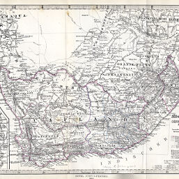
Das Capland nebst den Süd-Afrikanschen Freistaaten und dem Gebiet der Hottentotten & Kaffern
Permalink
https://digital.library.illinois.edu/items/322571a0-e946-0133-1d3d-0050569601ca-6
This item is in the public domain.
Descriptive Information
| Title | Das Capland nebst den Süd-Afrikanschen Freistaaten und dem Gebiet der Hottentotten & Kaffern |
| Creator | Habenicht, Hermann, 1844-1917 |
| Date | 1868 |
| Dimensions | 24.7 x 40.5 cm |
| Cartographic Scale | 1:5,000,000 |
| Notes | Relief shown by contours, hachures and soundings. Includes 1 inset map (scale 1:150,000): Die Capstadt und Umgebung. |
| Coverage-Spatial | Transvaal (Colony) |
| Subject | |
| Genre | Maps |
| Language | German |
| Color | Hand colored |
| Technique | Lithography |
| Source | Petermanns geographische Mitteilungen, V. 14, plate 2. |
| Physical Location | stx |
| Map No. in Bassett and Scheven Bibliography | 1668 |
| Call Number | Q_910_5PE |
| Map ID | afm0001668 |
| Rights | No Copyright - United States |
| Rights Description | This item is in the public domain. |
| Collection Title | Maps of Africa to 1900 |
| Repository | Rare Book & Manuscript Library |
| Type | Cartographic material |
| Collection | Maps of Africa to 1900 |
Download Options
|
Das Capland nebst den Süd-Afrikanschen Freistaaten und dem Gebiet der Hottentotten & Kaffern |
Contact us
for questions and to provide feedback.