
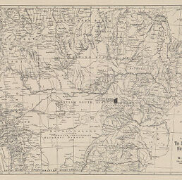
Plan Showing position of the Sutton, Simpson, Anderson, Blasson, and Gosling Blocks
Permalink
https://digital.library.illinois.edu/items/32310970-e946-0133-1d3d-0050569601ca-6
This item is in the public domain.
Descriptive Information
| Title | Plan Showing position of the Sutton, Simpson, Anderson, Blasson, and Gosling Blocks |
| Creator | Naumann, C. |
| Date | 1866 |
| Dimensions | 24.2 x 37.8 cm |
| Place of Publication | Germany |
| Cartographic Scale | 1:8,400,000 |
| Coverage-Spatial | Africa, Southern |
| Genre | Maps |
| Language | English |
| Color | Bitonal |
| Technique | Lithography |
| Source | Meyer's Hand-Atlasder neuesten Erdbeschreibung in 100 Karten, between plates 89-90. |
| Physical Location | stx |
| Map No. in Bassett and Scheven Bibliography | 1664 |
| Call Number | F_912M575 |
| Map ID | afm0001664 |
| Rights | No Copyright - United States |
| Rights Description | This item is in the public domain. |
| Collection Title | Maps of Africa to 1900 |
| Repository | Rare Book & Manuscript Library |
| Type | Cartographic material |
| Collection | Maps of Africa to 1900 |
Download Options
|
Plan Showing position of the Sutton, Simpson, Anderson, Blasson, and Gosling Blocks |
Contact us
for questions and to provide feedback.