
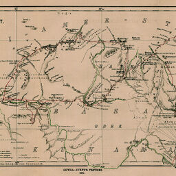
Itinerar-Aufnahmen im Aegyptisch-Abessinischen Grenzgbiet, ausgeführt von Josef Menges, Januar bis April 1881
Permalink
https://digital.library.illinois.edu/items/3259e1f0-e946-0133-1d3d-0050569601ca-e
This item is in the public domain.
Descriptive Information
| Title | Itinerar-Aufnahmen im Aegyptisch-Abessinischen Grenzgbiet, ausgeführt von Josef Menges, Januar bis April 1881 |
| Creator | Barich, Carl |
| Date | 1884 |
| Dimensions | 20.4 x 48 cm |
| Place of Publication | Germany |
| Cartographic Scale | 1:500,000 |
| Notes | Relief shown by hachures. Routes indicated by color. |
| Coverage-Spatial | Eritrea |
| Subject | |
| Genre | Maps |
| Language | German |
| Color | Printed color |
| Technique | Lithography |
| Source | Petermanns geographische Mitteilungen, V. 30, plate 8. |
| Physical Location | stx |
| Map No. in Bassett and Scheven Bibliography | 863 |
| Call Number | Q_910_5PE |
| Map ID | afm0000863 |
| Rights | No Copyright - United States |
| Rights Description | This item is in the public domain. |
| Collection Title | Maps of Africa to 1900 |
| Repository | Rare Book & Manuscript Library |
| Type | Cartographic material |
| Collection | Maps of Africa to 1900 |
Download Options
|
Itinerar-Aufnahmen im Aegyptisch-Abessinischen Grenzgbiet, ausgeführt von Josef Menges, Januar bis April 1881 |
Contact us
for questions and to provide feedback.