
Algérie et Tunisie
Permalink
https://digital.library.illinois.edu/items/326e4110-e946-0133-1d3d-0050569601ca-b
This item is in the public domain.
Descriptive Information
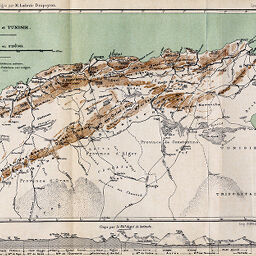
| Title | Algérie et Tunisie |
| Creator | Revue Géographique Internationale |
| Date | 1884 |
| Dimensions | 17.9 x 29.3 cm |
| Place of Publication | France |
| Cartographic Scale | 1:5,000,000 |
| Notes | Relief shown by form lines. |
| Coverage-Spatial | Tunisia |
| Subject | |
| Genre | Maps |
| Language | French |
| Color | Printed color |
| Technique | Lithography and aquatint (?) |
| Source | Revue de géographie, V. 15, between pp. 80-81. |
| Physical Location | stx |
| Map No. in Bassett and Scheven Bibliography | 867 |
| Call Number | 910_5RE |
| Map ID | afm0000867 |
| Rights | No Copyright - United States |
| Rights Description | This item is in the public domain. |
| Collection Title | Maps of Africa to 1900 |
| Repository | Rare Book & Manuscript Library |
| Type | Cartographic material |
| Collection | Maps of Africa to 1900 |
Download Options
|
Algérie et Tunisie |
Contact us
for questions and to provide feedback.