
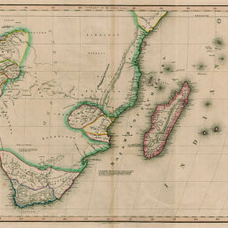
Part of Africa
Permalink
https://digital.library.illinois.edu/items/32787d70-e946-0133-1d3d-0050569601ca-4
This item is in the public domain.
Descriptive Information
| Title | Part of Africa |
| Creator | Lizars, W. H. (William Home), 1788-1859 |
| Date | 1830-1839 |
| Dimensions | 39 x 44 cm |
| Place of Publication | England |
| Cartographic Scale | 1:11,100,000 |
| Notes | Relief shown by hachures. |
| Coverage-Spatial | Africa, Eastern |
| Subject | |
| Genre | Maps |
| Language | English |
| Color | Hand colored |
| Technique | Etched or engraved |
| Source | Loose sheet |
| Physical Location | max |
| Map No. in Bassett and Scheven Bibliography | 1629 |
| Call Number | G8400183-?_L5 (not G8402 1830 _L5?) |
| Map ID | afm0001629 |
| Rights | No Copyright - United States |
| Rights Description | This item is in the public domain. |
| Collection Title | Maps of Africa to 1900 |
| Repository | Rare Book & Manuscript Library |
| Type | Cartographic material |
| Collection | Maps of Africa to 1900 |
Download Options
|
Part of Africa |
Contact us
for questions and to provide feedback.