


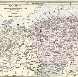
N.W. Africa Marocco Algeria & Tunis
Permalink
https://digital.library.illinois.edu/items/32c01370-e946-0133-1d3d-0050569601ca-b
This item is in the public domain.
Descriptive Information
| Title | N.W. Africa Marocco Algeria & Tunis |
| Creator | Cram, George Franklin, 1841-1928 |
| Date | 1889 |
| Dimensions | 17 x 29 cm |
| Place of Publication | United States |
| Cartographic Scale | 1:7,440,000 |
| Notes | Relief shown by hachures. |
| Coverage-Spatial | Tunisia |
| Subject | |
| Genre | Maps |
| Language | English |
| Color | Printed color |
| Technique | Lithography |
| Source | People's Illustrated, p. 172. |
| Physical Location | stx |
| Map No. in Bassett and Scheven Bibliography | 906 |
| Call Number | Q_912P3911889 |
| Map ID | afm0000906 |
| Rights | No Copyright - United States |
| Rights Description | This item is in the public domain. |
| Collection Title | Maps of Africa to 1900 |
| Repository | Rare Book & Manuscript Library |
| Type | Cartographic material |
| Collection | Maps of Africa to 1900 |
Download Options
|
N.W. Africa Marocco Algeria & Tunis |
Contact us
for questions and to provide feedback.