
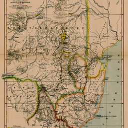
Kartenskizze von Zulu-Land und den Goldfeldern der Südafrikanischen Republik...von H. Haevernick, Pretoria, 1884
Permalink
https://digital.library.illinois.edu/items/340bc3f0-e946-0133-1d3d-0050569601ca-9
This item is in the public domain.
Descriptive Information
| Title | Kartenskizze von Zulu-Land und den Goldfeldern der Südafrikanischen Republik...von H. Haevernick, Pretoria, 1884 |
| Creator | Schmidt, C. |
| Date | 1885 |
| Dimensions | 43.7 x 32 cm |
| Cartographic Scale | 1:850,000 |
| Notes | Relief shown by hachures. |
| Coverage-Spatial | Orange Free State |
| Subject | |
| Genre | Maps |
| Language | German |
| Color | Printed color |
| Source | Petermanns geographische Mitteilungen, V. 31, plate 6. |
| Physical Location | stx |
| Map No. in Bassett and Scheven Bibliography | 1716 |
| Call Number | Q_910_5PE |
| Map ID | afm0001716 |
| Rights | No Copyright - United States |
| Rights Description | This item is in the public domain. |
| Collection Title | Maps of Africa to 1900 |
| Repository | Rare Book & Manuscript Library |
| Type | Cartographic material |
| Collection | Maps of Africa to 1900 |
Download Options
|
Kartenskizze von Zulu-Land und den Goldfeldern der Südafrikanischen Republik...von H. Haevernick, Pretoria, 1884 |
Contact us
for questions and to provide feedback.