
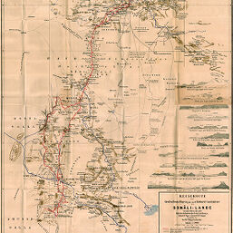
Reiseroute der Grafen Ernst Hoyos jun. und Richard Coudenhove im Somâli-Lande (November 1893 bix März 1894)
Permalink
https://digital.library.illinois.edu/items/34748690-e946-0133-1d3d-0050569601ca-5
This item is in the public domain.
Descriptive Information
| Title | Reiseroute der Grafen Ernst Hoyos jun. und Richard Coudenhove im Somâli-Lande (November 1893 bix März 1894) |
| Creator | Paulitschke, Philipp, 1854-1899 |
| Date | 1894 |
| Dimensions | 73.2 x 55 cm |
| Place of Publication | Austria |
| Cartographic Scale | 1:1,100,000 |
| Notes | Relief shown by hachures and spot heights. Includes 12 elevation profiles. Explorers routes indicated by color. |
| Coverage-Spatial | Horn of Africa |
| Subject | |
| Genre | Maps |
| Language | German |
| Color | Printed color |
| Technique | Lithography and aquatint (?) |
| Source | Mitteilungen der Österreichischen Geographischen Gesellschaft, V. 37, between pp. 422-423. |
| Physical Location | stx |
| Map No. in Bassett and Scheven Bibliography | 1467 |
| Call Number | 910_5GEOW |
| Map ID | afm0001467 |
| Rights | No Copyright - United States |
| Rights Description | This item is in the public domain. |
| Collection Title | Maps of Africa to 1900 |
| Repository | Rare Book & Manuscript Library |
| Type | Cartographic material |
| Collection | Maps of Africa to 1900 |
Download Options
|
Reiseroute der Grafen Ernst Hoyos jun. und Richard Coudenhove im Somâli-Lande (November 1893 bix März 1894) |
Contact us
for questions and to provide feedback.