
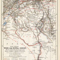
Das Obere Webi-und Djuba-Gebiet neueste italienische Forschungen in den Galla-Somali-Grenzaländer...
Permalink
https://digital.library.illinois.edu/items/3480ee50-e946-0133-1d3d-0050569601ca-9
This item is in the public domain.
Descriptive Information
| Title | Das Obere Webi-und Djuba-Gebiet neueste italienische Forschungen in den Galla-Somali-Grenzaländer... |
| Creator | Fritzsche, G. E. |
| Date | 1894 |
| Dimensions | 24.9 x 19.9 cm |
| Place of Publication | Germany |
| Cartographic Scale | 1:4,000,000 |
| Notes | Relief shown by shaded contours. |
| Coverage-Spatial | Italian Somaliland |
| Subject | |
| Genre | Maps |
| Language | German |
| Color | Printed color |
| Technique | Lithography |
| Source | Petermanns geographische Mitteilungen, V. 40, plate 9. |
| Physical Location | stx |
| Map No. in Bassett and Scheven Bibliography | 1459 |
| Call Number | Q_910_5PE |
| Map ID | afm0001459 |
| Rights | No Copyright - United States |
| Rights Description | This item is in the public domain. |
| Collection Title | Maps of Africa to 1900 |
| Repository | Rare Book & Manuscript Library |
| Type | Cartographic material |
| Collection | Maps of Africa to 1900 |
Download Options
|
Das Obere Webi-und Djuba-Gebiet neueste italienische Forschungen in den Galla-Somali-Grenzaländer... |
Contact us
for questions and to provide feedback.