
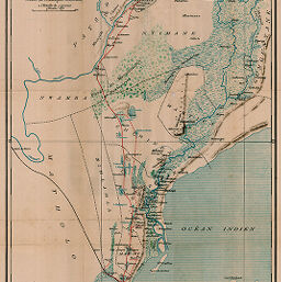
Carte du Nkomati inférieur et du district portugais de Lourenço Marques
Permalink
https://digital.library.illinois.edu/items/348c0ab0-e946-0133-1d3d-0050569601ca-0
This item is in the public domain.
Descriptive Information
| Title | Carte du Nkomati inférieur et du district portugais de Lourenço Marques |
| Creator | Grandjean, A. |
| Date | 1892 |
| Dimensions | 53.8 x 37.9 cm |
| Place of Publication | Switzerland |
| Cartographic Scale | 1:250,000 |
| Notes | Relief shown by landform drawings. |
| Coverage-Spatial | Portuguese East Africa |
| Subject | |
| Genre | Maps |
| Language | French |
| Color | Printed color |
| Technique | Lithography and aquatint |
| Source | Bulletin de la Société Neuchâteloise de géographie, V. 7, between pp. 112-113. |
| Physical Location | stx |
| Map No. in Bassett and Scheven Bibliography | 1400 |
| Call Number | 910_6SON |
| Map ID | afm0001400 |
| Rights | No Copyright - United States |
| Rights Description | This item is in the public domain. |
| Collection Title | Maps of Africa to 1900 |
| Repository | Rare Book & Manuscript Library |
| Type | Cartographic material |
| Collection | Maps of Africa to 1900 |
Download Options
|
Carte du Nkomati inférieur et du district portugais de Lourenço Marques |
Contact us
for questions and to provide feedback.