


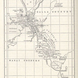
Sketch Map of Eastern Equatorial Africa, from Zanzibar to Lake Victoria Nyanza
Permalink
https://digital.library.illinois.edu/items/34afb050-e946-0133-1d3d-0050569601ca-8
This item is in the public domain.
Descriptive Information
| Title | Sketch Map of Eastern Equatorial Africa, from Zanzibar to Lake Victoria Nyanza |
| Creator | Thomson, Joseph, 1858-1895 |
| Date | 1885 |
| Dimensions | 13.1 x 9.6 cm |
| Place of Publication | England |
| Cartographic Scale | 1:9,500,000 |
| Notes | Relief shown by hachures. |
| Coverage-Spatial | Kenya |
| Subject | |
| Genre | Maps |
| Language | English |
| Color | Bitonal |
| Technique | Lithography |
| Source | The Journal of the Manchester Geographical Society, V. 1, p. 166. |
| Physical Location | stx |
| Map No. in Bassett and Scheven Bibliography | 1275 |
| Call Number | 910_6MA |
| Map ID | afm0001275 |
| Rights | No Copyright - United States |
| Rights Description | This item is in the public domain. |
| Collection Title | Maps of Africa to 1900 |
| Repository | Rare Book & Manuscript Library |
| Type | Cartographic material |
| Collection | Maps of Africa to 1900 |
Download Options
|
Sketch Map of Eastern Equatorial Africa, from Zanzibar to Lake Victoria Nyanza |
Contact us
for questions and to provide feedback.