
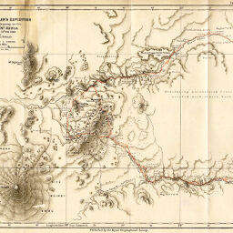
Wm. Astor Chanler's Expedition Route Map of a journey to the East of MT. Kenia 5th. Dec. 1892- 10th. Feb. 1893
Permalink
https://digital.library.illinois.edu/items/34f62e30-e946-0133-1d3d-0050569601ca-4
This item is in the public domain.
Descriptive Information
| Title | Wm. Astor Chanler's Expedition Route Map of a journey to the East of MT. Kenia 5th. Dec. 1892- 10th. Feb. 1893 |
| Creator | Höhnel, Ludwig, Ritter von, 1857-1942 |
| Date | 1893 |
| Dimensions | 21.8 x 32.6 cm |
| Place of Publication | England |
| Cartographic Scale | 1:1,000,000 |
| Notes | Relief shown by contours. Chanler's route indicated in red. |
| Coverage-Spatial | Kenya, Mount (Kenya) |
| Subject | |
| Genre | Maps |
| Language | English |
| Color | Printed color |
| Technique | Lithography |
| Source | The Geographical Journal, V. 1, between pp. 576-577. |
| Physical Location | stx |
| Map No. in Bassett and Scheven Bibliography | 1436 |
| Call Number | 910_5GJ |
| Map ID | afm0001436 |
| Rights | No Copyright - United States |
| Rights Description | This item is in the public domain. |
| Collection Title | Maps of Africa to 1900 |
| Repository | Rare Book & Manuscript Library |
| Type | Cartographic material |
| Collection | Maps of Africa to 1900 |
Download Options
|
Wm. Astor Chanler's Expedition Route Map of a journey to the East of MT. Kenia 5th. Dec. 1892- 10th. Feb. 1893 |
Contact us
for questions and to provide feedback.