
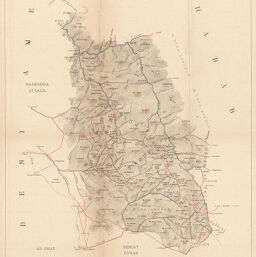
Carta dimostrativa della regione dei Maria
Permalink
https://digital.library.illinois.edu/items/356deae0-e946-0133-1d3d-0050569601ca-d
This item is in the public domain.
Descriptive Information
| Title | Carta dimostrativa della regione dei Maria |
| Creator | Società Geografica Italiana |
| Date | 1892 |
| Dimensions | 27.8 x 37.7 cm |
| Place of Publication | Italy |
| Cartographic Scale | 1:500,000 |
| Coverage-Spatial | Africa, Eastern |
| Genre | Maps |
| Language | Italian |
| Color | Printed color |
| Technique | Lithography |
| Source | Bollettino della Societa geografica italiana, ser. 3, V. 5, between pp. 476-477. |
| Physical Location | stx |
| Map No. in Bassett and Scheven Bibliography | 1419 |
| Call Number | 910_6SORSER_3 |
| Map ID | afm0001419 |
| Rights | No Copyright - United States |
| Rights Description | This item is in the public domain. |
| Collection Title | Maps of Africa to 1900 |
| Repository | Rare Book & Manuscript Library |
| Type | Cartographic material |
| Collection | Maps of Africa to 1900 |
Download Options
|
Carta dimostrativa della regione dei Maria |
Contact us
for questions and to provide feedback.