
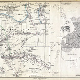
Originalkarte von M.v. Beurmann's Reise von Bengasi nach Mursuk & Wau, 13. Februar bis 6. Juni 1862 Plan von Mursuk
Permalink
https://digital.library.illinois.edu/items/35d0e6a0-e946-0133-1d3d-0050569601ca-e
This item is in the public domain.
Descriptive Information
| Title | Originalkarte von M.v. Beurmann's Reise von Bengasi nach Mursuk & Wau, 13. Februar bis 6. Juni 1862 Plan von Mursuk |
| Creator | Hassenstein, Bruno |
| Date | 1863 |
| Extent | 2 maps on 1 sheet |
| Dimensions | 24.6 x 42.8 cm |
| Place of Publication | Germany |
| Cartographic Scale | 1:3,500,000 |
| Notes | Relief shown by hachures. Plan of Murzuq is at scale of 1:6,666. Includes 2 inset maps (scale 1:2,000,000): Umgegend von Bengasi -- M. V. Beurmann's Reise von Mursuk nach Gatron und Wau. |
| Coverage-Spatial | Fezzan (Libya) |
| Subject | |
| Genre | Maps |
| Language | German |
| Color | Hand colored |
| Technique | Lithography |
| Source | Petermanns geographische Mitteilungen, V. 2, between pp. 96-97. |
| Physical Location | stx |
| Map No. in Bassett and Scheven Bibliography | 731 |
| Call Number | Q_910_5PE |
| Map ID | afm0000731 |
| Rights | No Copyright - United States |
| Rights Description | This item is in the public domain. |
| Collection Title | Maps of Africa to 1900 |
| Repository | Rare Book & Manuscript Library |
| Type | Cartographic material |
| Collection | Maps of Africa to 1900 |
Download Options
|
Originalkarte von M.v. Beurmann's Reise von Bengasi nach Mursuk & Wau, 13. Februar bis 6. Juni 1862 Plan von Mursuk |
Contact us
for questions and to provide feedback.