
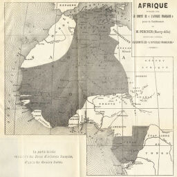
Afrique publiée par le Comité (L'Afrique Française)...
Permalink
https://digital.library.illinois.edu/items/36518a70-e946-0133-1d3d-0050569601ca-2
This item is in the public domain.
Descriptive Information
| Title | Afrique publiée par le Comité (L'Afrique Française)... |
| Creator | Société de Géographie de Toulouse |
| Date | 1892 |
| Dimensions | 24.6 x 23.9 cm |
| Place of Publication | France |
| Cartographic Scale | 1:10,600,000 |
| Notes | Indicates zones of French influence. |
| Coverage-Spatial | Africa, French-speaking Equatorial |
| Subject | |
| Genre | Maps |
| Language | French |
| Color | Bitonal |
| Technique | Lithography |
| Source | Bulletin de la Société de Géographie de Toulouse, V. 11, between pp. 268-269. |
| Physical Location | stx |
| Map No. in Bassett and Scheven Bibliography | 412 |
| Call Number | 910_6SOCT |
| Map ID | afm0000412 |
| Rights | No Copyright - United States |
| Rights Description | This item is in the public domain. |
| Collection Title | Maps of Africa to 1900 |
| Repository | Rare Book & Manuscript Library |
| Type | Cartographic material |
| Collection | Maps of Africa to 1900 |
Download Options
|
Afrique publiée par le Comité (L'Afrique Française)... |
Contact us
for questions and to provide feedback.